
The densest neighborhood in the city overlaps with the most tree canopy coverage in the city.
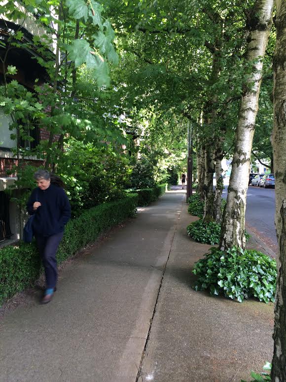
I love my Capitol Hill neighborhood in the spring. The tree canopy, the tree canopy, the magical tree canopy!
The quantity & quality of Seattle’s tree canopy is a proxy for the city’s endless existential debate over density: Opponents of increased density say increasing development diminishes canopy, and I say the city’s tree canopy is flourishing right now, in the heat of a development boom.
I can’t help thinking tree canopy is consistent with density because I live in one of the city’s densest, multi-family zones, and whenever I’m out walking or biking, I’m repeatedly startled by how green my neighborhood is. (The Heart of Capitol Hill , with 54,850 people per square mile is the densest section of Seattle; though on average, Belltown, First Hill, and Lower Queen Anne are denser at 38,000 people per square mile, 27,000 people per square mile, and 16,000 people per square mile respectively versus Capitol Hill’s 15,000 people per square mile on average.)
 5/31/17
It turns out my sense that density overlaps with heavy tree canopy isn’t just my anecdotal inkling of things.
The Seattle Office of Sustainability & the Environment’s 2016 Seattle Tree Canopy Assessment found that my neighborhood is in the section of the city with the highest percentage of canopy coverage, 36 percent canopy coverage. (I’m leaving out “Delridge Neighborhood” in Southwest Seattle, which truly came in 1st place at 38 percent, because it includes the largest swaths of dedicated green space in the city.)
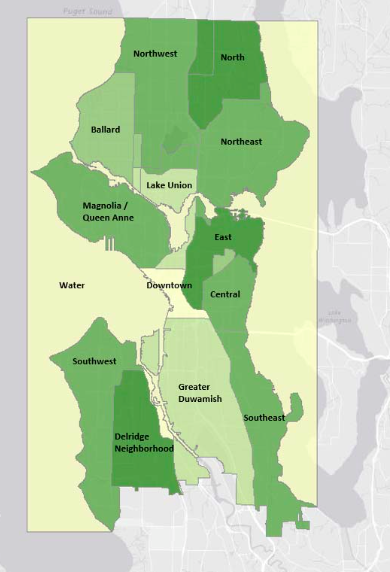
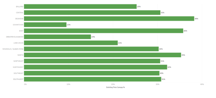
The study certainly isn’t precise about neighborhoods; my Capitol Hill neighborhood, for example, simply fits into a broader region that’s labeled “East.” But the study also showed that all the regions with larger single-family zones—”Ballard,” “Central,” “Northwest,” “Northeast,” “Southeast,” “Southwest,” and “North”—all have lower canopy coverage than the “East” region.
Admittedly, at 35 percent canopy coverage, the “North” Seattle region—the region that has the most exclusively single-family zoning—comes in a close second place to my “East” region. But still, with “North” Seattle coming in second to “East” Seattle (which, including super dense First Hill, has significantly more land zoned multi-family than the “North,” according to the report), I’d say the burden of proof in the great tree canopy debate lands on the people who disparage density for its supposed negative impact on greenery.
I should note: The study did find that adding development slightly lowered canopy coverage in single-family zones. However, that finding came with a big asterisk saying the finding was “not statistically valid.”
Ultimately, the study DOES say single-family zones have more tree canopy coverage than multi-family zones…
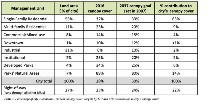
But the study also says this: A dominant 56 percent of the city is zoned “Single-Family Residential” … versus just 11 percent zoned “Multi-Family Residential”… This means (with so much more land to start with!) the “Single-Family” zones have more of the City’s parks, green spaces, and school play fields overall to factor into the greenery mix.
Footnote: It’s important to remember that property owners in single-family zones have the rights to cut down trees in their yards. People in multi-family zones don’t have that leeway. That’s probably why my multi-family neighborhood is so wild with trees.
6/3/17

Howdy Josh,
Don’t fall into the trap of thinking the location of a tree is as important as it’s quality.
Trees that are maintained in good condition can live twice as long as neglected trees.
What is needed is to keep records of our contact with each tree in a citywide database.
The planning department currently requires a map of all trees on every property that has a building permit application on file. Unfortunately, the city ‘throws away’ this information by failing to compile it into a tree inventory.
Instead, the city ‘takes a picture’ every 5-10 years with satellite photos that exclude information on maintenance needs, value, type of tree, conflicts with utilities, and other important info.
http://invw.org/2016/07/27/seattles-long-neglected-tree-canopy-is-on-a-collision-course-with-development/
LikeLike
“It’s important to remember that property owners in single-family zones have the uncontested right to cut down trees in their yards.”
This is not correct. Under SMC 25.11.040 and 060, SF lots that are 5,000 sq. ft. or larger are subject to restrictions on tree removal similar to those applicable in MF zones. The “tip sheet” explains this clearly: “Tree removal on developed land is limited in all lowrise, midrise, and commercial zones and on single-family lots 5,000 square feet in area or larger as follows…” http://www.seattle.gov/DPD/Publications/CAM/cam242.pdf
LikeLike
I stand corrected on saying the right to cut down trees is “uncontested,” but there are plenty of exemptions…you can, for example, cut down 3 non-exceptional trees 6″ in diameter, per year. Here’s the full code: http://www.seattle.gov/dpd/codesrules/codes/treeprotection/default.htm.
LikeLike
Josh, while you say that the area shown as “East” in the report has a high amount of tree canopy, you misrepresent where that tree canopy exists in the East area.
Much of East’s tree canopy is in its large parks: the Arboretum, Interlaken Park, and Volunteer Park which together are about 300 acres (and since, other than Lake Union, East is the smallest of all the city areas, those parks are a higher percentage). Plus, the greatest area of tree canopy in residential areas of the East is the single family area east of 19th and large chucks of Lake Washington Blvd.
You also left out the part of the report (page 14) which shows that there is more than 25% tree loss in single family areas due to development. That’s not people cutting down their own trees, that’s developers doing the chopping.
In terms of real tree canopy the numbers are far worse than that 25% because the developers take down mature trees and replace them with new trees that will take years to reach the beauty and air cleaning capacity of the previous trees, but for the numbers the new trees still count the same as the old trees.
LikeLike
Hey David. Thanks for the comment. I thought the same thing at first. But as the report shows, the “East” section doesn’t have more green space than the areas that have more single-family zones. Agreed, though, the results here are imprecise.
LikeLike